




Executive Overview
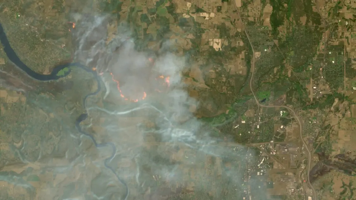
In an important development for environmental monitoring, disaster response, and open-source intelligence, high-resolution wildfire and smoke-tracking capabilities have officially become a native feature of the European Space Agency’s (ESA) Copernicus Browser. Previously accessible only to advanced geospatial analysts and technical researchers who manually injected custom visualization scripts, this sophisticated remote-sensing tool is now immediately available to the public as a default layer option.
The integration was spearheaded by Simon Proud, a mission scientist for the Sentinel-2 program at the ESA. Proud successfully advocated for the script’s inclusion to streamline how researchers, journalists, and emergency managers visualize atmospheric particulates and active thermal anomalies. He formally announced the successful integration within a dedicated community Discord channel operated by Bellingcat, the renowned investigative journalism collective.
This enhancement arrives at a critical juncture. Globally, traditional wildfire seasons are lengthening, intensifying, and increasingly threatening human infrastructure and ecosystems due to the compounding pressures of global climate change. While various space-based assets already exist to monitor blazes—such as NASA’s Fire Information for Resource Management System (FIRMS)—they often suffer from limitations in spatial granularity. Sentinel-2’s high-resolution multi-spectral bands bridge this gap, offering a spatial resolution down to 10 meters. As wildfires ravage regions from the Pacific Northwest of the United States and the Canadian boreal forests to the Mediterranean basins of France and Spain, the democratization of high-fidelity satellite data marks a significant milestone in earth observation and crisis response.
Detailed Chronology: From Manual Workarounds to Default Integration
The Era of Manual Customization
Before this default integration, utilizing specialized scripts to visualize complex atmospheric phenomena like smoke plumes, aerosol optical depth, and sub-surface thermal combustion signatures in the Copernicus Browser required technical proficiency. Users had to navigate the platform’s developer infrastructure, locate vetted codebases, and manually copy-paste scripts into the "custom visualization" parameter under the default layers menu.
While effective for power users, data scientists, and specialized OSINT (Open-Source Intelligence) investigators, this friction point largely kept the capability out of the hands of frontline journalists, local emergency planners, and the general public. Extracting actionable intelligence from raw multi-spectral data demanded a foundational understanding of band math and JavaScript-based Sentinel Hub Evalscripts, limiting the democratization of earth observation data.
The Push for Accessibility
Recognizing the immense value of these advanced visualization scripts during active environmental crises, ESA Sentinel-2 mission scientist Simon Proud initiated an institutional push to integrate the script directly into the core Copernicus Browser architecture. The objective was clear: remove technical barriers so that anyone—from a local newsroom to a wildfire management analyst—could instantly render high-resolution views of smoke and burn scars without writing or copying a single line of code.
The Announcement and Community Reception
The culmination of this effort was quietly yet effectively communicated to the geospatial and investigative communities. Simon Proud took to a specialized server on the communication platform Discord—specifically, a community hub managed by Bellingcat—to break the news.
The announcement was met with immediate enthusiasm from open-source researchers, environmental watchdogs, and conflict-monitoring groups who routinely rely on Sentinel-2 data to verify ground truths, track environmental warfare, and map disaster zones in real time. By embedding the script natively, the ESA has effectively transformed the Copernicus Browser from a technical data archive into an intuitive, plug-and-play disaster response dashboard.
Supporting Context & Metrics: Comparing Global Satellite Constellations
To understand the magnitude of this integration, it is essential to contextualize Sentinel-2 within the broader ecosystem of satellite-based Earth observation assets dedicated to wildfire and smoke detection.
NASA’s FIRMS: Broad Coverage, Coarser Resolution
For years, NASA’s Fire Information for Resource Management System (FIRMS) has served as the gold standard for global fire tracking. Powered by sensors such as the Moderate Resolution Imaging Spectroradiometer (MODIS) aboard the Terra and Aqua satellites, and the Visible Infrared Imaging Radiometer Suite (VIIRS) aboard NOAA-20 and Suomi NPP, FIRMS provides an invaluable, rapidly updated global map of thermal anomalies.
- Update Frequency: Extremely rapid, with new data refreshed within several hours of satellite overpasses.
- Spatial Resolution: Coarser resolutions, generally down to 250 meters per pixel (and up to 375 meters to 1 kilometer depending on the specific sensor and band).
- Primary Utility: Exceptional for macro-level tracking, early detection of remote fires, and establishing broad geographical perimeters of smoke transport across continents.
Sentinel-2: High-Resolution Precision
Conversely, the European Union’s Copernicus Sentinel-2 mission—comprising a constellation of two polar-orbiting satellites (Sentinel-2A and Sentinel-2B)—approaches Earth observation from a different technical paradigm. While its temporal resolution is lower than NASA’s polar-orbiting daily sweeps (with imagery over a specific location updated every few days), its spatial resolution is peerless among free, publicly available datasets.
- Update Frequency: Every 2 to 5 days depending on latitude and cloud cover.
- Spatial Resolution: High-resolution multi-spectral imagery in certain bands down to 10 meters spatial resolution.
- Primary Utility: Unmatched for detailed tactical assessments. A 10-meter resolution allows analysts to pinpoint individual burning structures, narrow down precise fire fronts, evaluate localized smoke density over specific valleys, and map post-fire burn scars with forensic accuracy.
The Apex of Free Public Tools
Because of this unique balance between high spatial fidelity and unrestricted public access, Sentinel-2 has evolved into the definitive open-source tool for monitoring complex terrestrial events. Beyond tracking the granular spread of wildfires, the platform’s high-resolution bands have proven vital for assessing infrastructure damage in active war zones, monitoring maritime illegal activity, and tracking environmental crimes. By bringing advanced smoke-visualization scripts into this ecosystem natively, the ESA has exponentially amplified the analytical power available to the global public.
Official Statements and Institutional Perspectives
The integration of advanced visualization tools into public-facing portals reflects a broader cultural and operational shift within space agencies: moving away from exclusive scientific stewardship toward participatory earth observation.
While space agencies have traditionally operated with a heavy focus on long-term scientific research, the realities of the Anthropocene have forced a pivot toward operational readiness. Mission scientists like Simon Proud represent a new vanguard of public servants who recognize that satellite data sitting in archival mainframes is of little use during an active climate catastrophe. By actively bridging the gap between raw data processing and intuitive user interfaces, ESA engineers are empowering civil society to participate directly in environmental accountability.
Furthermore, investigative networks like Bellingcat have repeatedly demonstrated that open-source intelligence—heavily reliant on platforms like the Copernicus Browser—can hold state and corporate actors accountable, verify humanitarian crises, and document the human cost of climate degradation. The informal yet strategic announcement via a Bellingcat-run Discord channel underscores the symbiotic relationship modern space agencies now share with decentralized, tech-savvy investigative communities.
Future Outlook: Wildfires, Climate Change, and the Next Generation of Earth Observation
As the world confronts an increasingly volatile climate future, the demand for high-resolution, accessible environmental monitoring tools will only accelerate. The current state of global wildfires illustrates a grim reality: traditional seasonal boundaries have dissolved into year-round emergencies.
A Global Crisis Without Borders
The urgency behind tools like the upgraded Copernicus Browser is underscored by unprecedented wildfire activity across multiple continents:
- North America: The Pacific Northwest—specifically Washington and Oregon—has repeatedly choked under dense, hazardous blankets of wildfire smoke originating from regional blazes and transboundary drift. Meanwhile, Canada is tracking what has historically become one of its most destructive and expansive wildfire seasons on record, consuming millions of acres of boreal forest and releasing staggering quantities of carbon into the atmosphere.
- Europe: Southern and Western Europe are no longer immune to extreme fire regimes. Countries like France and Spain have experienced record-breaking heatwaves and prolonged droughts, prompting massive evacuations of hundreds of thousands of residents as fast-moving crown fires overwhelm traditional firefighting infrastructure.
Emerging Technologies and the Horizon
Looking ahead, the geospatial landscape is expanding rapidly. The recent launch of Google-backed satellite constellations engineered specifically for early wildfire detection signals that private capital is rushing to supplement public infrastructure. These commercial constellations promise even faster revisit rates and specialized infrared payloads designed to catch ignition events before they erupt into uncontrollable megafires.
However, commercial barriers, subscription models, and proprietary data restrictions often keep these advanced commercial tools out of reach for local communities, regional NGOs, and independent journalists. Consequently, open-access public programs like Europe’s Copernicus initiative remain the bedrock of global environmental transparency.
Conclusion
The integration of advanced smoke-tracking scripts by default into the Copernicus Browser is more than a minor software update; it is a vital upgrade to humanity’s collective situational awareness. By lowering technical barriers and placing high-resolution, 10-meter observation power directly into the hands of researchers, journalists, and emergency responders, the European Space Agency and scientists like Simon Proud have fortified the global community’s ability to witness, document, and respond to the escalating fires of a warming world. As climate change continues to rewrite the rules of our natural environment, open, accessible, and high-fidelity satellite data will remain one of our most powerful defenses.